
Operational activities
Seismicity analysis
Section titled “Seismicity analysis”Seismic events are detected and analyzed using real-time data from the seismological stations of Epos-France, as well as from networks in neighboring countries (Germany, the United Kingdom, Belgium, Spain, Italy, Luxembourg, and Switzerland). The waveforms (seismograms) recorded by the instruments at Epos-France stations are distributed by the Epos-France seismological data center and the European EIDA portal. The BCSF-Rénass also uses data from temporarily deployed seismological networks to detect increased seismic activity (aftershocks following a major earthquake, seismic swarms, etc.) or for research purposes such as AlpArray (AlpArray seismic network, Hetényi et al., 2018) or those of citizen seismology projects using RaspberryShake-type stations (Schlupp, Chavot, et al., 2019).
For every seismic event detected, BCSF-Rénass calculates rapid preliminary locations (automatic and unvalidated locations) and publishes them on the website. During business hours, these are reviewed by a seismologist (manual and validated locations, distinguishing between natural and anthropogenic earthquakes).
Since 2012, seismicity analysis has been carried out using SeisComP software with the LocSAT earthquake location program (Bratt and Nagy, 1991). For localization, depending on the geographical area concerned, several velocity models are used: an average model for mainland France (Haslach, Rothé, and Peterschmitt, 1950), and specific models for the Pyrenees (Pauchet et al., 1999), the Alps (Thouvenot et al., 2003), and the Massif Central (Mazabraud et al., 2005), etc.
In addition to natural earthquakes, the service also detects any event that generates seismic waves. Consequently, one of the important steps in analyzing the recordings is to differentiate, or discriminate, between signals from natural earthquakes and those from anthropogenic events or other natural events (landslides, rockfalls, etc.). The unnatural events detected are mainly related to quarrying activities, but also to sea mine clearance explosions or events induced by underground mining. They are labeled according to their identified or presumed origin. Discrimination is based on the experience of seismic analysts (presence of low-frequency surface waves, ratio of P-wave amplitude to S-wave amplitude, very shallow depths), but also relies on deep learning algorithms and additional available information such as proximity to a quarry or communications from maritime authorities (mine clearance operations). For induced events, discrimination is currently based on objective criteria such as proximity to an underground mining site, information on ongoing industrial operations, and knowledge of local geology (faults) and past seismicity in the region (Davis and Frohlich, 1993).
Several regional observatories (OMP-Toulouse, OSUG-Grenoble, OCA-Nice, and OSUNA-Nantes) contribute, on a more or less regular basis, to the BCSF-Rénass’s seismicity monitoring activities in mainland France. Regarding overseas territories, BCSF-Rénass incorporates earthquake locations provided by IPGP-OVS and Révosima.
The BCSF-Rénass locates several thousand events per year in mainland France and in border areas (a significant proportion of which are quarry blasts). The increase in the number of Epos-France stations since 2016 has led to a lowering of the magnitude detection threshold for events.
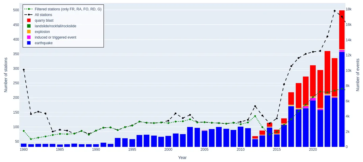
Annual change in the number of events located by BCSF-Rénass between 1980 and 2024 Since 2012, events have been differentiated according to their origin: natural earthquakes (blue), quarry blasting (red), explosions (yellow), landslides (green), and induced earthquakes (pink). The black curve represents the number of stations that contributed to the locations (present in the bulletins), while the green curve represents the number of Epos-France stations, including the FR, RA, RD, FO, and G networks.

Evolution of the density of local earthquake magnitudes between 1980 and 2024
Macroseismic analysis
Section titled “Macroseismic analysis”In order to assess the severity of ground shaking (EMS-98 intensity) in the event of earthquakes widely felt in France, the BCSF-Rénass collects macroseismic data (effects on people, objects, furniture, and buildings). This data is translated into terms of macroseismic intensity of ground shaking (severity of shaking on the EMS-98 scale from I to XII) at the municipal level.
This data is collected from citizens via survey forms on the website as soon as an earthquake occurs, enabling a quick, automatic preliminary estimate of the EMS-98 intensity in each municipality. Anyone who felt the effects of the earthquake can fill out a survey form. People located in the area affected by the earthquake who did not feel any particular effects are also invited to fill it out.
In the event of earthquakes with a magnitude greater than 3.7, a survey is conducted among local authorities (town halls, police stations, fire departments) via the prefectures of the departments affected by the earthquake using a dedicated web interface. In the event of significant damage to buildings, the BCSF-Rénass intervenes on the ground in the affected municipalities by mobilizing the Macroseismic Intervention Group (GIM) to accurately assess EMS-98 intensities based on the extent of damage according to the seismic vulnerability of buildings. This group, led by BCSF-Rénass, is made up of around 60 trained experts from various organizations involved in seismological studies (mainly from Epos-France). Teams are operational in mainland France and the French West Indies.
The basic data for validated and definitive EMS-98 intensity estimates are those collected from the authorities, as they provide a statistical overview at the municipal level. Individual reports are included in the estimate when there are enough of them to be representative of the municipality. If data has been collected by the GIM (on-site observations by experts), it takes precedence over other sources when estimating intensity.
These macroseismic surveys also provide a better understanding of the spatial variations of seismic shaking (local effects, decay with distance), enable the calibration of historical earthquakes (estimating the magnitude of past events), etc. They are also an important decision-making tool for elected officials and civil engineers involved in earthquake-resistant construction, seismic hazard assessment, earthquake-resistant standards, etc.
Scientific collaborations with European seismological observatories are established in the event of an earthquake in border areas, particularly for GIM intervention.
The BCSF-Rénass is the body responsible for producing the scientific reports used by the DGSCGC (Direction générale de la sécurité civile et de la gestion des crises) to process requests from municipalities for recognition of a state of natural disaster (“Cellule interministérielle de catastrophe naturelle”).
ShakeMaps Production
Section titled “ShakeMaps Production”The BCSF-Rénass produces “ShakeMaps” - maps of ground shaking levels - for widely felt earthquakes, using the ShakeMap program developed by the USGS. Ground shaking can be represented by different units: intensity (EMS-98), PGA (peak ground acceleration), PGV (peak ground velocity), PSA (pseudo-spectral acceleration).
This mapping is based on numerical modeling using:
- the characteristics of the event (location, depth, magnitude);
- models of wave propagation and attenuation in the ground with distance;
- site effects (amplification effects related to local conditions);
- instrumental measurements from seismological networks (Epos-France, as well as seismological observatories in neighboring countries);
- municipal intensities deduced from available macroseismic data (EMS-98 intensities)
Instrumental and macroseismic data are complementary. Instrumental data are available in real time for permanent stations, of which there are around 400 across mainland France, some of which are located in urban areas, the main targets of seismic hazard and risk. Macroseismic data from citizen reports, on the other hand, arrive spread out over time, increasing in the minutes, hours, and days following the earthquake, but are available in all 35,000 French municipalities. As a result, the preliminary intensities derived from this data are generally the only data readily available within the first 15 to 20 kilometers around the epicenter (except in cases of significant damage).
The ShakeMap published on the website is updated regularly to include the latest instrumental and macroseismic data. A consolidated version, based on citizen reports, is generally available one week after the earthquake. The reference ShakeMap is calculated after all the data has been verified and validated, including the consolidated location of the earthquake, the addition of other instrumental measurements, and the final macroseismic intensities obtained from surveys of the authorities and estimated by the GIM where applicable. This reference ShakeMap is published later and for the strongest earthquakes.
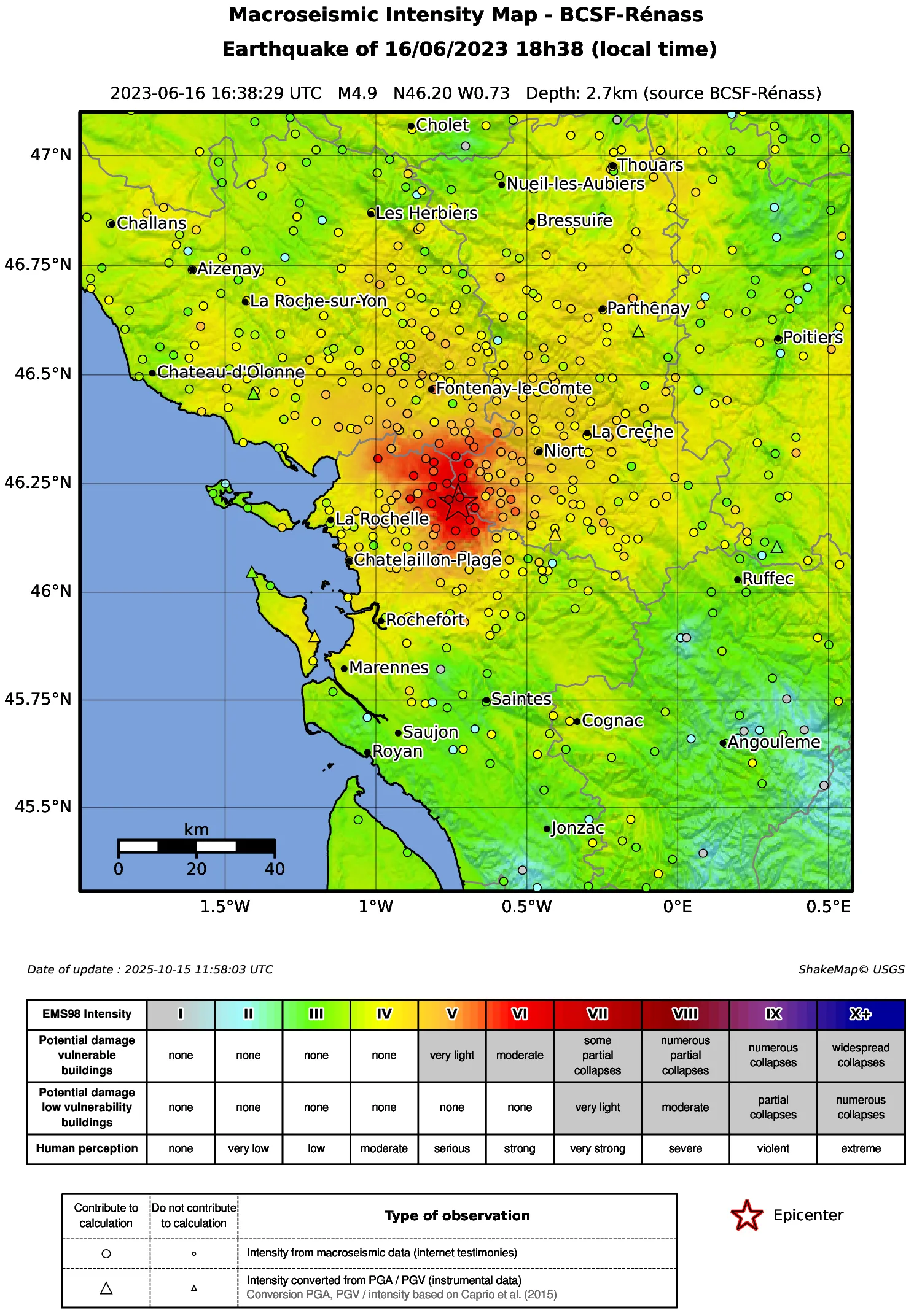
Reference ShakeMap for the La Laigne earthquake, June 16, 2023.